-
Trekking
-
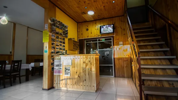
Accommodation -
Self-Guided -
Transfers -
Meals
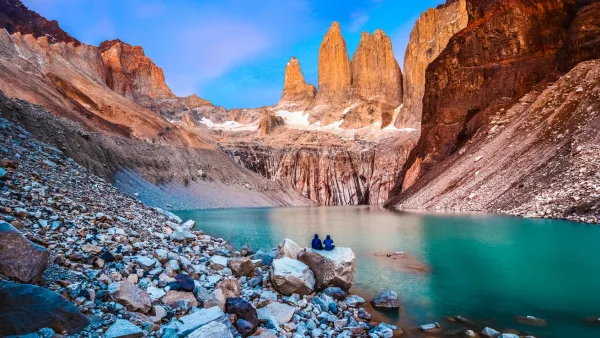
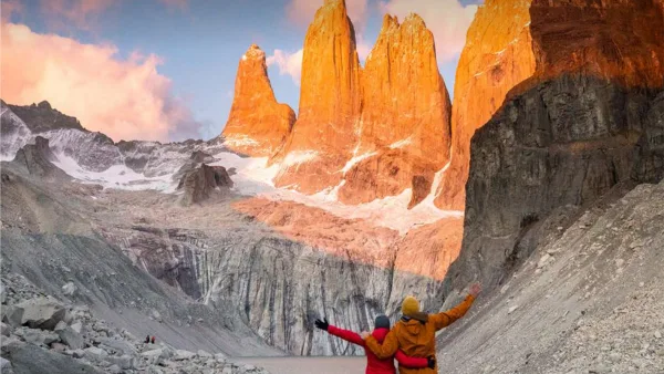
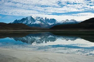
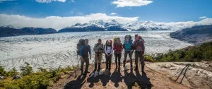
Discover the O Classic Circuit, the most comprehensive and challenging hiking experience in Torres del Paine.
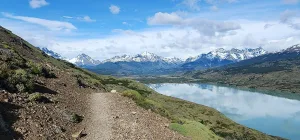
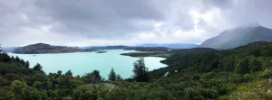
Over the course of 8 days, you’ll traverse the entire Paine Massif, exploring remote areas of the park, Patagonian forests, glaciers, rivers, lakes, and some of Patagonia’s most breathtaking landscapes, including John Garner Pass, the Grey Glacier, the French Valley, and the Torres Base Camp.
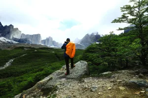
Unlike the W Circuit, the O Circuit allows you to discover the wildest and least explored side of Torres del Paine, traversing less-visited areas and physically more demanding stages.
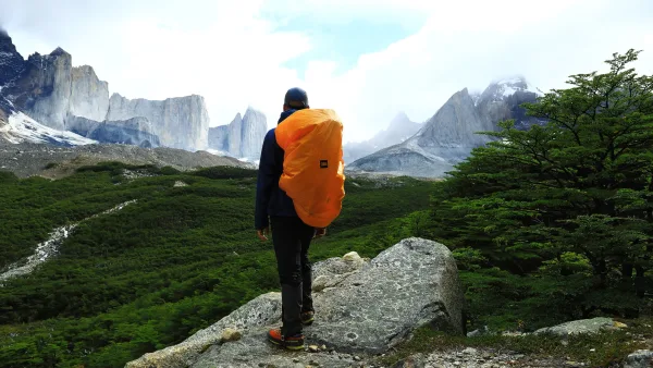
This self-guided program is designed for travelers with prior experience in multi-day trekking and good physical fitness, combining adventure, nature, and an immersive experience in Patagonia.
It includes lodging, meals, and transfers, allowing you to focus entirely on the journey and the experience.
Duration: 8 days / 7 nights
Approximate distance: 120–130 km
Program type: Self-guided trek
Fitness level: High
Technical level: Intermediate
Recommended minimum age: 10 years
Due to high demand and limited availability within the park, especially between November and March, we recommend booking in advance.
You can secure your spot with a deposit, subject to availability.
Itinerary
Loss: 250 meters
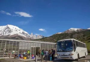
Start of the program at the bus terminal
After breakfast at the hotel, you must to go to the bus terminal to take the 7:00 am bus (we recommend being at least 10 minutes before departure) to go to Torres del Paine National Park.
Bus trip to the National Park
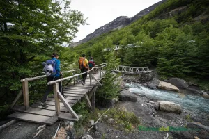
You will travel through beautiful landscapes until you reach the main entrance, Laguna Amarga, where it is necessary to register with CONAF (park rangers).
Entrance to the Nacional Park
Information gates: The Laguna Amarga and Río Serrano gates will remain in operation throughout the year. They will control the entrance of visitors, as well as provide orientation and information to those who require it.
Transfer to Las Torres Sector
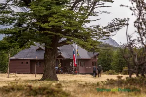
Here you will transfer to "Las Torres" shuttle, who will take you to the Visitor’s Center. Check yourself in at the Cerro Paine Reserve.
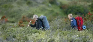
Trek to Serón Sector
Enjoy this 13.5-km point-to-point route near Torres del Paine, Magallanes. It is generally considered a moderate route, taking an average of 3 h 40 min to hike. It is a popular region for backpacking, camping and hiking, so it is likely to meet other people while in the area. The best time to visit this route is from October to
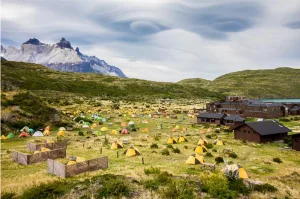
Overnight in Serón Campground
Located 4 hours trek from Las Torres sector, it’s in the Eastern side of the National Park, where begins the Big Circuit.
Loss: 300 meters
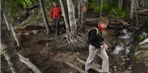
Departure for a trail walk to the Dickson Sector
Trail for use in one direction only.
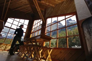
Shelter or Camping Accommodation in Dickson
This shelter and campground are located on the banks of the Dickson Lake and is the farthest point of the O Circuit in the Torres del Paine National Park. Located in one of the sectors with greater vegetation of the park has some of the most beautiful views of the entire circuit. Trails are reaching the Dickson area from the
Loss: 250 meters
Trail for use in one direction only.
Overnight at Los Perros Campground
This campsite is located just before John Gardner Pass, at 550 m.s.n.m. Belongs to Circuit O of Torres del Paine. From this point you can access the Punta Puma Glacier. There are basic toilet facilities and cold water showers only. Services Grocery Store There is a warehouse provided with everything necessary for snacks and basic supplies. Quincho It is a
Loss: 1200 meters
Trek from Los Perros to Paso Gardner
Trail for use in one direction only.
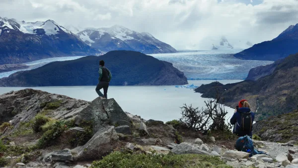
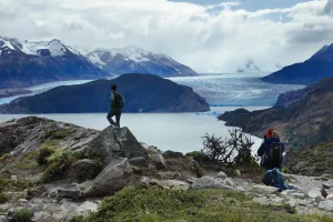
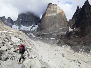
Trek to the Grey Sector
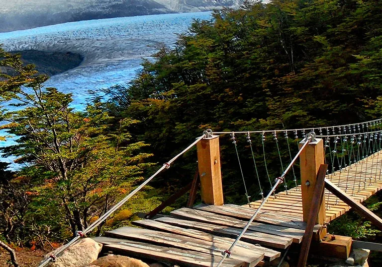
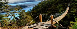
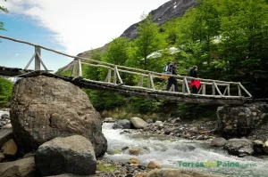
Passing the Glacier, the hard descent begins, the path continues along a narrow path until entering the forest until reaching the Conaf El Paso Nursery, approximately 1 hour and a half walk from the Glacier, on the way it crosses three hanging bridges and after 4 hours or so from the Conaf El Paso nursery you arrive at the Gray
Night of accommodation in Grey Shelter or Campground
This shelter is few minutes away from the glacier Grey, which emerges from the Southern Ice Fields. It is on one end of the W trekking circuit, the best known and busiest of Torres del Paine National Park, and you can access it by walking from the Shelter Vértice Paine Grande, in catamaran from the Hosteria Lago Grey or from
Loss: 500 meters
Discover this 22.2-km round-trip route near Torres del Paine, Magallanes. It is generally considered a difficult route, taking an average of 6 hours 28 minutes to travel. It is a very popular region for backpacking, camping and hiking, so you are likely to meet other people while you are in the area. The best time to visit this route is
Night of accommodation in Paine Grande Shelter or Campground
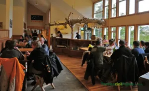
The shelter is located on the banks of the Pehoé Lake in the area of the old shelter Pehoé, off the south side of Cerro Paine Grande. It is part of the W circuit, and it is the ultimate base camp of Torres del Paine. It is a strategic place in the park, which is only accessible through the lake
Loss: 700 meters
This circuit begins from the Paine Grande Ferry Dock on Lake Pehoe. Continue along the Trail to the Italian Camp, which surrounds Lake Skottsberg on the west bank. Once at the camp, you can spend the night or return the same day (it is not a very long route). The return is along the east bank of the lake. Throughout
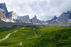
Enjoy this 3.7-km round-trip route near Torres del Paine, Magallanes. It is generally considered a difficult trail. It is a very popular region for hiking, so you are likely to meet other people while you are in the area. One of the most beautiful valleys in the Torres del Paine National Park The French Valley Trek is part of the
This hike has a constant elevation gain, but the views down to the valley, the Francés Glacier, and the Cuernos de Paine (on the way back) are unbeatable. If you are doing the W circuit tour, it will be a point-to-point walk. The idea and return route is generally used for a day hike. Check out this 10.3-km round-trip route
This trail connects the Italian Camp, the gateway to the beautiful French Valley with the Los Cuernos camp area, which receives its name because it is located at the foot of the hills that protrude from the Paine Mountain Range as if they were horns. Also pass by the French camp which has a pleasant restaurant on the shores of
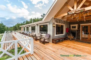
Night of accommodation in Los Cuernos Shelter, Cabins or Campground
Located at the Base of “Los Cuernos” of Paine Massif, 4.5 hours trek from Las Torres area. The site presents an unbeatable view of the Cuernos and Nordenskjöld Lake, becoming and excellent place to recover and continue the journey. It’s on the heart of the W Circuit, and is the place to stay during the second or third night depending
Loss: 300 meters
The trail to Mirador Cuernos also known as Cuernos del Paine offers a short and easy hike surrounded by some of the stunning landscapes of Chilean Patagonia.
Accommodatio in Torre Central Campground or Shelter
Located in Las Torres area at the beginning of the W Circuit. From this place you have access to Base of the Towers trail and then continue to Los Cuernos and French Valley. Access is by the Laguna Amarga entrance to Torres del Paine, from where you may take a minibus that brings visitors to the sector.
Loss: 899 meters
This route connects the Refugio Chileno, Laguna Inge and finally Refugio Los Cuernos through the trails "Las Torres a Chileno" and "Atajo Chileno a Los Cuernos". It is possible to appreciate incredible landscapes and walk among Patagonian forests next to the Ascencio River, in the vicinity of Lake Nordenskjöld and with views of the impressive mountain formations such as Mount
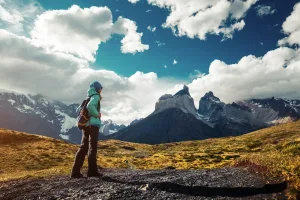
Difficulty: Medium - 20 km (8 hours) Initial altitude: 90 meters above sea level Maximum altitude: 870 meters above sea level The hike to Mirador Base Las Torres (or simply Mirador Torres) is one of the most iconic in Chilean Patagonia and probably the most popular within the Torres del Paine National Park. It allows you to have incredible views
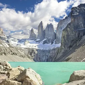
The preamble to access the Torres del Paine A wonder of nature. We arrive at the closest point to appreciate the characteristic mountains of this park after crossing suspension bridges, crossing slopes, walking through lenga forests and ascending between rocks to the viewpoint that is 700 mm above sea level. From here the view is impressive: you have a wonderful
Return on the same way to Las Torres Sector
Transfer to Amarga Lagoon
Bus from Amarga Lagoon to Puerto Natales
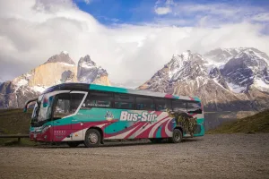
Travel comfortably and affordably between Puerto Natales and Torres del Paine National Park using the most popular regular shuttle service for travelers and trekkers visiting Patagonia. (more…)
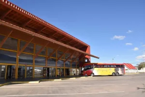
Back at the Bus Terminal of Puerto Natales
When you are at the Puerto Natales Bus Terminal, remember to take care of your belongings, especially during busy times. Pay attention to bus arrivals, as most terminals do not provide real-time arrival information. Several bus companies, such as Buses Pacheco, Bus Sur, Buses María José, Buses Fernández, and Buses Cootra, operate from this terminal. The terminal also offers several
Frequently Asked Questions
The O Circuit Torres del Paine lasts 8 days and 7 nights. During the program, travelers complete the full Paine Massif route, including remote areas of the park and some of its most important highlights, such as John Garner Pass, Grey Glacier, the French Valley and Base Torres.
The duration is defined by the program itinerary and the logistics of accommodation, transfers, meals and hikes inside Torres del Paine National Park.
The O Circuit is a longer, more complete and more demanding route than the W Circuit. While the W Circuit covers the park’s most iconic areas, the O Circuit goes around the entire Paine Massif and includes more remote, less crowded and physically demanding sections.
It is recommended for travelers looking for a multi-day trekking experience, a deeper connection with nature and a more challenging route within Torres del Paine.
The O Circuit is a program with a high physical difficulty level. It includes several hours of hiking each day, with trekking days that can range from 4 to 12 hours, depending on the section of the itinerary.
The route includes long ascents, uneven terrain, mud, rocks, mountain passes and changing weather conditions typical of Patagonia. For this reason, it is recommended for travelers in good physical condition and with previous trekking experience.
Yes. Previous experience in multi-day trekking is recommended. The O Circuit is not an introductory program, as it includes long stages, remote areas and highly demanding sections such as John Garner Pass.
To enjoy the experience safely, it is important to be used to hiking with a backpack, dealing with changing weather conditions and keeping a steady pace for several consecutive days.
This program is operated in a self-guided format, with the main logistics organized: accommodation, meals, transfers and park access.
Although you will not be accompanied by a guide throughout the entire route, it is essential to follow the indicated itinerary, respect departure and arrival times, hike only on authorized trails and follow the instructions of park rangers and local operators inside the park.
Included
-
Round Trip Bus Tickets Puerto Natales – Torres del Paine
Round trip in regular shared service without a guide. - Shared transfer between Laguna Armaga and Sector Las Torres
-
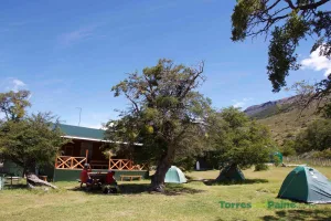
1 night in Sector Serón
Camping includes: tent and mountain sleeping bag and insulating mat. -
1 night in Dickson Sector
Camping includes: tent and mountain sleeping bag and insulating mat. Shelter includes: armed bed or single bed (with sleeping bag). -
1 night in Sector Los Perros
Camping includes: tent and mountain sleeping bag and insulating mat. -
1 night in Sector Grey
Camping includes: tent and mountain sleeping bag and insulating mat. Shelter includes: armed bed or single bed (with sleeping bag). -
1 night in Sector Paine Grande
Camping includes: tent and mountain sleeping bag and insulating mat. Shelter includes: armed bed or single bed (with sleeping bag). -
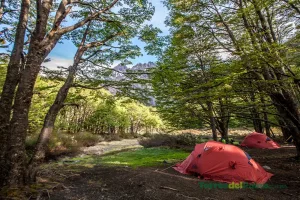
1 night in French Sector or Cuernos
(Depending on availability) Camping includes: tent and mountain sleeping bag and insulating mat. Shelter includes: armed bed or single bed (with sleeping bag). -
1 night accommodation in Central Sector
Camping includes: tent and mountain sleeping bag and insulating mat. Shelter includes: armed bed or single bed (with sleeping bag). - Full board (breakfast, box lunch, and dinner)
-
Ticket for O circuit trails
• Typical duration: 7 to 9 days. • Type of visit: Full trek around the Paine massif. • Sectors included: W Circuit + additional sectors of the park. • Permitted activities: Full trekking with multiple overnight stays. • Key requirement: Mandatory campsite/refuge reservations for each night. • Recommended profile: Experienced trekkers, good physical condition, and advanced planning. -
Expert advice and coordination
Personalized guidance and coordination of your experience via phone, email, webchat, WhatsApp, and scheduled video calls. -
Booking Fee – Reservation Management
Included in the final price. This fee covers the administrative expenses associated with managing and confirming the reservation, processing payments, and coordinating the service with local operators.
General Conditions
Restrictions and Recommendations
- This program is not recommended for children under 10 years of age.
- Passengers over 70 years old must present a medical certificate stating they are in adequate physical condition for the program's activities, ensuring a pleasant experience for everyone.
- Passengers must be able to carry their personal belongings for the duration of the program.
- We recommend the use of 40 liter backpacks.
- We offer custody in Puerto Natales for those who wish to leave their luggage.
Recommendations for trekking
- Bring extra clothes inside the dry bag (socks, first layer, quick-drying pants).
- Use of backpacks to transport food and the aforementioned elements. (One backpack per passenger with a minimum capacity of 15 liters is recommended).
- Inform physical condition at the time of carrying out the activity (recent fractures or injuries, allergies, recent or ongoing medical treatments, drug dependence, etc.).
Pricing
| Per Person | Price for Chileans and Residents | Price for non-resident Foreigners |
|---|---|---|
| Camping en Single | CL$ 1 621 000 | US$ 2 593 |
| Camping en Doble | CL$ 1 343 000 | US$ 2 065 |
| Refugio | CL$ 1 430 000 | US$ 2 420 |
| Camping en Single | CL$ 2 041 000 | US$ 3 088 |
| Camping en Doble | CL$ 1 564 000 | US$ 2 381 |
| Refugio | CL$ 1 912 000 | US$ 3 165 |
| Camping en Single | CL$ 2 407 000 | US$ 3 415 |
| Camping en Doble | CL$ 1 892 000 | US$ 2 629 |
| Refugio | CL$ 2 098 000 | US$ 3 267 |
Commercial Conditions
Cancellation Policies
- Cancellations with 91 days or more before arrival: 90% refund.
- Cancellations between 90 and 71 days before arrival: 80% refund.
- Cancellations with 70 days or less before arrival are not eligible for a refund.
Other Conditions
- For groups of more than 15 people, special conditions may apply regarding payment amounts, cancellation deadlines, and refund percentages. These conditions will be communicated in advance at the time of booking and will be defined on a case-by-case basis, depending on the characteristics of the group.
Our apply on everything not mentioned before.
Request with GreatChile
O Circuit Torres del Paine
This site is protected by reCAPTCHA and the Google Privacy Policy and Terms of Service apply.
Questions? Contact GreatChile
Office Hours
- Checking office status...
Telephone
Agenda
- Experts Appointment